 A
brief history of
A
brief history of
The Stoughton Turnpike
Incorporated June 23, 1806
and the
Taunton and South Boston Turnpike
Incorporated June 24, 1806
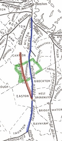
Taunton & South Boston Turnpike (Blue)
Stoughton Turnpike Corporation
THE TAUNTON AND
SOUTH BOSTON TURNPIKE
The Taunton and South Boston Turnpike Corporation was created by act of June 24, 1806, with the right to build a road
from
Taunton Green, so called, . . . nearly on a straight line to the crossway
over the Great Cedar Swamp, so called, and from thence over said crossway
near to the house of Joshua Gilmore in Easton, and from thence through the
towns of Bridgewater and Stoughton, the most direct and convenient route
to the Blue Hill Turnpike.
Petitions
entered late in 1806 resulted in the location of the road and in awards of
damages during the year 1807. The report of the committee within the
county of Bristol is found in full on the records in Taunton, and gives
some interesting data on a subject generally indefinite.
The
length of the road in that county was 9. 11 miles, of which 3.08 miles, or
33 8/10 per cent, was built on land which the owners freely gave to the
corporation. Twenty-three per cent of the right of way was obtained by
purchase at an agreed price, details of which are not given; while, with
the owners of 43 2/10 per cent of the needed land, no agreement could be
reached, and the corporation was obliged to condemn the land and have the
price fixed by the committee. That was done on twenty‑nine parcels
covering a length of twelve hundred and fifty-eight rods, on which the
committee appraised the damage at a total of $2009. The corporation
through a director, Samuel Fales, appealed from two of the awards
and succeeded in obtaining, a total reduction of twenty- five dollars.
Thus, from the figures actually available, we see that the right of way in
Bristol County cost about $505 a mile, or at the rate of about $63 an
acre.
Two
hundred and seventy-five rods of the way was through the Great Cedar
Swamp, which occupies portions of Bridgewater, West Bridgewater, Easton,
Raynham, and Taunton, swinging in a big semicircle northerly and westerly
from Nippenicket Pond in Bridgewater to Scadding Pond in Taunton. The
cedar swamps of southeastern Massachusetts
plainly were not designed for road building. The straight, slender cedars
grow so thickly that only the fittest survive, and the ones that die are
so tightly wedged in the living mass that they cannot fall, but continue
to stand, ghostlike, greatly increasing the difficulty of cutting a way
through. One may walk at one moment on firm soil and then suddenly step
through a hole so deep that the length of his leg does not locate the
bottom. Soundings have determined the hard bottom in several of these
swamps to be anywhere from six inches to thirty feet below the surface,
with water almost always within the depression made by a footstep. The
surface is composed of a network of large roots, generally so thickly
woven that the soil is held between them, but always liable to yield
through a larger hole when a careless foot marks its center. Through such
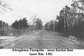
an inferno the builders of the Taunton
and South Boston Turnpike had the courage to make .86 mile of their road.
And it was the obstacle presented by this cedar swamp to the building of
earlier roads which gave the opportunity for a turnpike to be built where
public funds could not be applied.
Enough
has already been said concerning the through route from
A
tollhouse long stood in Raynham, near the
Twenty-one
and a half miles were built at a cost of $ 34,434.61, or about $1600 a
mile. Returns were made to the state house from 1810 to 1849, as shown on
the chart herewith. The showing is remarkably poor, the gross earnings
never running as high as three per cent, while the expenses were generally
close to them and often in excess.
An
act passed in 1817 shows that this road suffered, too, from “shunpikers,”
for a penalty is there laid for all practicing such evasions.
Kingman's
“History of North Bridgewater” (Brockton) testifies that at one time
there was a heavy travel over this road, both of freight and passengers.
The
The
act incorporating the Stoughton Turnpike Corporation June 23, 1806, is
noteworthy for being the first one in which the judgment of the persons
investing the money is mentioned as a factor to determine the location of
the road. This company was to build from a point in the “Old Bay Road”
in Canton, about two miles beyond the westerly end, of the Brush Hill
Turnpike, to a point on the Taunton and South Boston Turnpike in the town
of Easton. It may be noted that the Taunton and South Boston, mentioned in
this act, was incorporated a day later, and had no actual existence at the
time, much less was there any such road.
December
13, 1806, the five disinterested freeholders of Bristol County were
appointed to locate the road, and in September, 1808, they reported, the
section in Norfolk County being located at the same time. But work did not
advance at once, and the company secured an extension of its time to June,
1813.
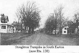
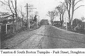
This
turnpike is now the state highway known as Turnpike Street in Canton, and
Washington Street in Stoughton and Easton. In its active days it offered a
through route from Taunton to Roxbury, except for the two miles
intervening between its northerly end and the end of the Brush Hill. At
the southerly end, as stated, it connected with the Taunton and South
Boston, which entered Taunton, and, by the construction of a later
turnpike, through turnpike travel to Providence was provided.
Such
a franchise as that of the Stoughton Turnpike would be almost impossible
to obtain at this time. It closely paralleled a direct route, half of
which was already built or under construction, with the other half seeking
incorporation and ready 7 to proceed. It depended upon another company for
entrance into Taunton and, by its connection, would take away one half of
that company’s through business. Evidently the principle of protecting
investments in public utilities was not then established.
The
Stoughton Turnpike Corporation was dissolved by act of the legislature in
March, 1839, and its road was laid out as a county highway in 1840, except
a portion in Stoughton, which was so laid out In 1856.
[Source: Frederic J. Wood, The Turnpikes of