CHAPTER III
CENTRAL AREA
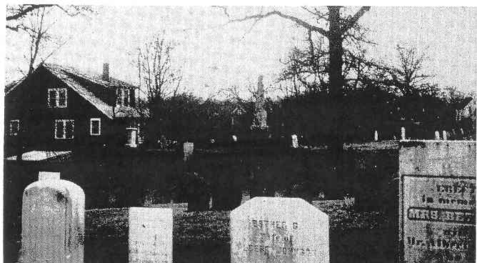
Pearl Street Cemetery
The Central area divides itself roughly into two loops, north and west of the Square and south and east of it. The first area approached from Bay Road via Plain Street includes Morton, Wyman, Washington, Canton, western Central, and Pearl Streets. Some of the most interesting houses to trace are located in this area. The second area centers around Sumner, Park, and lower Pleasant Streets. Together, these locations contain some of the oldest houses in Stoughton
Beginning on Morton Street, at 270 Morton Street is a farmhouse built in 1783 by Ambrose Morton. It was dated by the Historical Society files printed in the News-Sentinel in 1934 under the heading, "Ancient Dwellings in Stoughton," which were probably compiled from the Capen collection. The 1790 census, first Massachusetts recorded census, lists Ambrose Morton in Stoughton; the map of 1794 places his home in this location. The house contains fireplaces both upstairs and downstairs, and pegged beams; it is said to have been "renovated" 100 years ago. Known locally as the Oxbow Farm, it was an active farm with grazing cows, within recent memory. Its huge barn was torn down a few years ago to make way for a street.
From a site at 165 Morton Street the 1741 house built by Isaac Paul was moved to 25 Bradford Street (a location picturesquely known as Toad Hill) about 1840. The Capen file reports that in its early history in 1745, the first regular public school in Stoughton was kept in one of its rooms. On the 1749 map, the Isaac Paul house is listed on Morton Street, built in 1741. The Capen file verifies that it was moved about 1840. The Lothrop name is also associated with this house; an Elijah Lothrop was mentioned in the early 1800's on Toad Hill. In more recent years, the house has been made into a two family house.
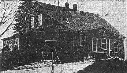
Just off Morton Street at 179 Wyman Street is the home of Israel Dickerman, built in 1821. The house can be located here on the 1831 map; the News-Sentinel file of 1934 also notes the name and date. Although Dickerman is a familiar name in the annals of Stoughton, no other information was available on this family.
A short distance away is the only early house on lower Washington Street, at 927 Washington Street. This small Cape style house was built in 1814 by Luther Clark, according to both the 1831 map and the News-Sentinel file of 1934. The name Luther Clark appears also on deed records for a house near the square on Washington Street in 1844 and 1853; apparently Luther Clark owned several pieces of property in the vicinity of the square.
Stephen Blake House was demolished in the early 1980's.The site is where a mini-mall and parking lot are in 2008.
North of the square on Washington Street is a small house, later added on to, at 605 Washington Street, which was built by Stephen Blake in 1807. Now two sections, 605 and 607, it is obvious that 605 is the original. It contains a central chimney with four fireplaces from it (now covered over) and a brick section in the sand cellar for storing food. It is located on the 1831 map and dated again in the Capen file.
From Stoughton Square toward West Stoughton, the old road was said to travel between courthouses from the Bridgewater area to Dedham; Pearl Street continued on to Canton and Dedham from Sumner and Park Streets. The Town Meeting of January 1796 ordered some road markers put up. "The 4th post, at the corner of the road on ye Plain between Rev. Edw. Richmond's and Maj. Robt Swan's with 2 boards thereon. The first board inscribed 30 miles to Plymouth through Bridgewater, the other board 4 miles to Easton." There was no Canton Street until 1850, when the present street was accepted as a town road "between Southworth's and Porter's." But houses were built in this area in the early years.
CORRECTION: This is not the oldest house in Stoughton This house was from West Street, but was not the Samuel Waters' house discussed below. It was moved to the Canton Street location as described. However Capt. Asa Waters discusses in a letter that the old house was torn down, and the one that was used to replace it in the 1840's was moved. This house which was moved is much altered now and no longer looks like it did in the 1980's.
The oldest house standing in Stoughton is a small cottage at 105 Canton Street with an interesting history. Built in 1731-34 by Samuel Waters on West Street, it was moved to its present site when it was "truly over 100 years old." Wm. Capen dated it 1731, but the Album says 1734. The 1749 map shows the Samuel Waters house at present 1053 West Street, built in 1734. The early tax list records Samuel Waters paid takes in 1733/1734, and 1737. The News-Sentinel file of 1934 states that Luther Drake later bought the property and built the present house at 1053 West Street. According to Capen, the old house was moved around 1846-48. Records of deeds in Dedham show that in 1835 Luther Drake bought land on West Street from Lewis Waters, who had bought it from Asa Waters. Capen clarifies this further, recording that Luther Drake sold the old building to Barney (Bernard) Ford, who moved it to Canton Street. It is also recorded in Dedham that Robert Porter sold land on Canton Street in 1849 and again in 1853 to Bernard ford; it can be assumed the old house was moved there some time between 1846 and 1853, where it now rests on a solid granite foundation.
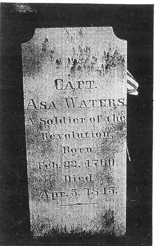
Capt. Asa Waters gravestone
Dry Pond Cemetery
The Waters family continued to live in the Dry Pond area. Samuel and Bethial Waters' son, Zebulon, was born in 1734 or 1735. Zebulon's son, Asa, was born in 1760. He joined the army at 16, and was recorded as living on Bay Road in 1792. Asa Waters was an uncle of Deborah Sampson, the famed Revolutionary War female soldier from Sharon. His son, Asa, is recorded as born in Stoughton in 1786. The West Street property still belonged to the Waters family in 1835 when Luther Drake purchased it.
The modest house at 281 Canton Street reflects a whole family history descended from the original owner, Thomas Crane, who built the house in 1771-74. It was built at 338 Canton Street and later moved towards the center of town. Thomas Crane was an important man in the Revolutionary days of Stoughton-Canton, serving as justice of the Peace, a delegate to the 2nd Provincial Congress in 1775, a Selectman, and a member of the General Court. Born in 1726 to Silas and Experience Crane in Milton, he lived in Ponkapoag for a while Huntoon calls him one of its most energetic and influential citizens. He married Mary Fenno in 1749; they had seven children. Huntoon reports Thomas owned a large tract of land between Belcher's Corner and West Stoughton The tax list in Stoughton records Thomas Crane was assessed for dwelling and land in 1771; Huntoon reports Crane moved to Stoughton in 1774. During the War, he was in charge of the powder mills, and collected funds and clothing for the war. In 1787 he left Stoughton for Milton, but continued to pay taxes on the land until his death in 1804. The Historical Society Album and the 1929 list from the map of 1775 both say Crane lived in his house in 1775 at 338 Canton Street, but the house was later moved to 281 Canton Street.
In tracing the vagaries of the Crane property a most interesting genealogy emerged, Thomas and Mary's children were Elijah, Ruth, Sarah, Mary, Abigail, Rebecca, and Thomas, Jr. Thomas, Jr. married Eunice Stone and produced six children before his untimely death. Thomas, Sr. left no will; his estate was administered by eldest son, Elijah, who bought up his sisters' share of land. Mary, Thomas, Sr.'s widow, received as her widow's dower considerable property in Stoughton, however. When she died in 1809, her will left 40 acres of land in Stoughton to her seven grandchildren by Thomas, Jr, (one daughter's share to her two children). The Crane girls, Elijah's sisters, married into Stoughton families and continued to live in Stoughton, their husbands buying up much of the Crane property. Sarah married Samuel Bird in 1782; Mary married Samuel Wales, who lived up on Pearl Street; and Abigail married Nathan Gill.
In 1799, there was land deeded from Elijah Crane to Samuel Bird, already married to his sister Sarah. Apparently Samuel and Sarah died at an early age, because their two daughters, Sally and Laura, became wards of their uncle Samuel Wales. When they came of age, he deeded their father's land to them as their dower. Meanwhile, some Samuel Bird property on Canton Street had been deeded to Stephen Drake (one record states 1805} and his wife, Vashti, "with house and 1/2 barn and corn barn." On the 1831 map the Bird house now belongs to V. Drake. One of Stephen and Vashti Drake's daughters was Roxanna Tucker, whose name appears later on the deed for the house at 281. In 1866 she sold it to Jeremiah Holland, when it passed out of the family, it appears that the house at 281 Canton Street is the Crane house, passed through the Birds to the Drakes
Elijah Crane also had two granddaughters, Mary Drake and Harriet Atherton. Elijah Crane's daughter, Harriet, married Elijah Atherton; several transactions passed and from Elijah Crane to Elijah Atherton. Mary Drake married Elijah Atherton's son. Both Mary and young Harriet Atherton inherited land from grandfather Elijah Crane in 1834, and were also mentioned in Elijah Atherton's will in 1849.
Through deeds and wills, one sees a glimpse of the relation of the Cranes, Drakes, Birds, Wales, and Athertons.
Continuing down Canton Street, we encounter one of Stoughton's influential families, the Southworths. The genealogy of the Southworth family is important in locating several houses in this area, which is still known as "Southworth territory." The patriarch of the Stoughton Southworths was Jedediah, born in 1745 in Bridgewater. At 20, he went to Harvard, but left after two years because of ill health. On July 12, 1770, he married Mary, daughter of Captain Consider Atherton; sometime around his marriage, he moved to Stoughton. He was one of Stoughton's Minute Men marching to Lexington with Capt. Wm, Briggs on April 19, 1775, He was also a member of the Constitutional Convention after the war. His wife, Mary, died in 1785; later, he married Mrs. Eunice Mills of Chesterfield and lived there in 1790. In 1801, however, he was recorded as living in Canton.
Jedediah's son, Consider, was born in 1778, in Chesterfield, one of twins. In 1799, Consider married Mary Hixon of Sharon; they resided in Stoughton, where his children Asahel, Amasa, Consider A., Jedediah, and Myra were born. Consider was a Colonel irs the Militia in the War of 1812, and although he was not called into action, he was subsequently referred to as Col. Consider Southworth.
Asahel, born in 1814, was a woolen yarn manufacturer. He was married three times: in 1839 to Harriet Kingsley, whose children were Consider, Mary Hixon, Marianna, and Harriet; in 1855 to Sarah Dodge Fellows, a widow, who bore a son, Elmer Kingsley Southworth, in 1858; and in 1872 to Mrs. Lydia Swift.
It is interesting to note that the family who owned the houses on Canton and Central Streets were mainly manufacturers; property changing hands among them often included a mill or factory. The tax lists for 1801 show Consider Southworth taxed for 1 Dwelling; in 1818, both Col. Consider and his brother Jedediah Southworth paid taxes; by 1826, Col. Consider paid taxes on three buildings and Jedediah on two. Col. Consider was said to have been the first to buy the right to peg shoes (a new invention) in Stoughton. In 1823, he started a cotton thread factory, later run by Consider A. and Amasa. Consider A. later started a cotton cord (used to finish boots and shoes) factory. He made the first cotton cord in Massachusetts manufactured by water power in 1814, Consider Southworth was deeded a large parcel of land in the general area of present Southworth Court, purchased from Consider Atherton. In 1842, Asahel Southworth bought from Consider Southworth a parcel .of land with "dwelling house, barn, thread factory, and outbuildings," adjacent to the 25 acres which was conveyed to Consider Southworth by Consider Atherton. This may have been the site of the French and Ward factory which was owned at one time by Consider Southworth. Many of the houses in that area were built by Southworths; at one time there were fourteen Southworth families living in Stoughton. They were obviously large landholders in this location, retaining some to farm. It was recorded that Amasa (born in 1807) was "early inured to labor, and for the most of his life worked diligently with both head and hands. His youth was passed assisting his father in farming and in the mill,"
The house at 530 Canton Street was the original Consider Southworth house built about 7607 at the site of 587 Canton Street. The Capen File and News-Sentinel list date it at 1796, and erroneously label it Asahel's; since Consider was not on the tax list until 1801, the Committee chose that as a building date. On the 1831 map, C, Southworth was located near Central Street; there was no Canton Street until 1850, when it was accepted "from Southworth's." Somewhere about 1854, the small house was moved from 587 to 530 Canton Street where Consider probably lived until his death in 1863. One of the recent owners of the property at 587 said he understood that the old house was cut in two, and one part was moved near Gill's factory and the other to "just below the corner of Canton Street and Southworth Court," At his father's death, Asahel inherited this property; he sold it in 1871 for $900 to James Taber who had married his daughter, Marianna, The 1876 map shows James Taber living here. The deeds trace directly from Taber to the present (1976) owner who has found original timbers marked in Roman numerals and at least one original glass window in the front of the house.
The confusion in dating the houses at these two sites on Canton Street arises from the fact that Asahel Southworth built the present house at 587, after the old house was moved closer to town by Consider. The recent owner believed the present house was built by Asahel about 1856 or 7; it appears in its present shape on the map of 1876, listed to A. Southworth, who lived there until his death in 1881. Consider A. may have owned the house at 587 for a short time, but later in the 1880's until 1890, Asahel's son, Elmer Kingsley Southworth, owned it. The Polycutt family purchased it from him and lived there many years.
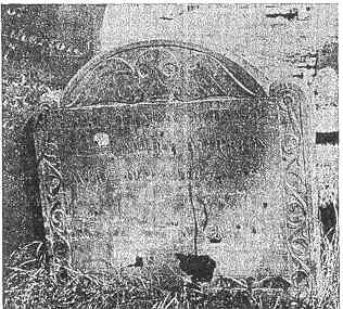
Humphrey Atherton (1672-1748)
Pearl Street Cemetery
Another venerable Stoughton family lived in this general area near Canton Street, the Athertons. Born in Dorchester about 1672, Humphrey Atherton was a constable there in 1700 and 1701. He married Elizabeth Withington in 1700; they had five children: Humphrey, Elizabeth (who married Ebenezer Mosely), John, Consider, and Anna, who married Edward Belcher. It was said Humphrey, Sr., had a good thirst; records in Dorchester show he confessed in church in 1708,1711, 1716, 1721, and 1726! About 1727, he moved to Stoughton, where he died in 1748, leaving a large estate including one negro, "Cuffee."
Humphrey's sons were all born in Dorchester; Humphrey, in 1707; John, in 1714; and Consider, in 1716 or 1719. "Capt." Humphrey appears to have returned to Dorchester; he died there in 1786. Brother John stayed in Stoughton; he was known as Deacon John, since he became a Deacon in the Stoughton Church. In 1741, he married Rachel Wentworth; they had a daughter, Elizabeth, who married Ebenezer Tucker; and a son, John, who married Mary Adams, the daughter of the beloved Rev. Jedediah Adams of Stoughton. Deacon John died in Stoughton in 1785. The youngest brother, Consider, born about 1719, married Mary Bailey in 1744 in Stoughton. Listed as a soldier in the Revolution, he was called Capt. His daughter, Mary, was married in 1770 to Capt. Jedediah Southworth. Consider is said to have died in Boston, but his gravestone is in Stoughton's oldest cemetery on Pearl Street, along with Humphrey and John. He lived, according to the marker, to the ripe old age of 93.
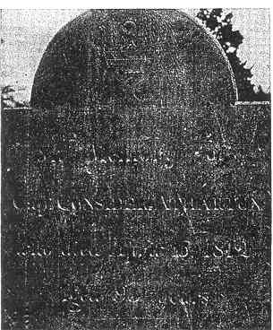
Capt. Consider Athartun (Atherton)
Pearl Street Cemetery
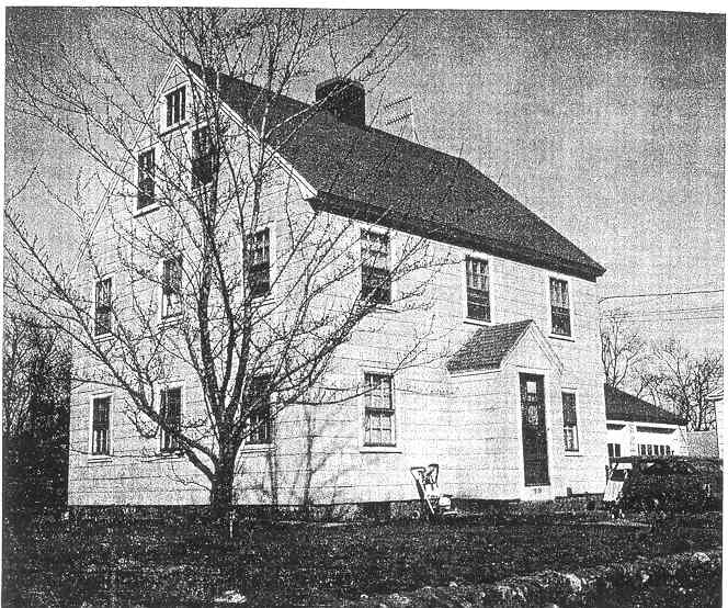
At 33-35 Pratts Court stands the house built by Consider Atherton in 1740. The Capen File dates it at 1740, but the 1775 map lists it at 1744. However, there is a house off Central Street in this location on the map of 1749, labeled Consider Atherton, 1740, which is the probable source of Wm. Capen's date and the accepted date herein. The house is marked also on the 1794 map as Considers. The history qf the house becomes vague after that, but it is generally acknowledged that, even though renovated and added on, the original house remains there.
Traveling northwest on Central! Street there are several dwellings built in the early 1800's. At 1678 Central Street is a fairly large house built by Simion Presbery in 1815. The News-Sentinel article and the Capen File both spell Simion's name "Presby" but agree on the date, 1814. On the 1831 map, which is the semi-official Stoughton map, the spelling is as the Committee accepted it, Presbery. According to a descendant of Simion's uncle, the correct spelling is Presbrey. The vital records of Taunton and Norton state Simion Presbrey was born in 1782, apparently in Norton. He lived in Stoughton, was a housewright and later, a thread manufacturer. In 1824 he moved to Canton where he died in 1858.
Nearby on a bend in the road, stands a Cape style cottage at 1716 Central Street, built by Luther Southworth in 1822. The Capen File dates it 1822-8, but the News-Sentinel list puts it definitely at 1822. The map of 1831 shows L. Southworth's house here; its position was turned slightly when the highway was put in. Luther was probably the son Luther born to Jedediah Southworth, brother of Consider, in 1799. Jedediah was a farmer living in Stoughton where all his children were born.
The Methodist Meeting House
This was demolished in 1987, and Gay' Factory Boarding house which stood south of it. The site is currently a mini-mall.
At 1829 Central Street is a plain two storied house which was built in 1818 as the first Methodist Meeting House in Stoughton. It was easily documented by Wm. Capen and the News-Sentinel as the M E Church, built in 1816. Interestingly, Huntoon has a brief notation that early in the 1800's there was a move in Canton (it is assumed generally in the area) to separate church and state; first it was voted "not to tax dissenters"; then, in 1819, Canton voted not to raise money from the town for the minister's support. Possibly this more liberal attitude attended the building of a Methodist church in Stoughton. On the 1831 map, the "Methodist M H" is shown, next to the small sleepy cemetery still to be seen in the churchyard. According to Frank Reynolds, the Drakes and Reynolds of this area attended the local Methodist Meeting House.
The house at 1960 Central Street was identified on the 1831 map as the John Low house, built in1809. Capen's file dates it 1809-12, but the News-Sentinel settled on 1809. There is no information beyond this on John Low.
Nathan Drake House - Demolished in the early 1990's
Off Central Street is a small street leading to a mill site along Steep Hill Brook called, appropriately, Mill Street. An historically interesting house is at 44 Mill Street, the farmhouse built by Nathan Drake in 1805. Shown on the map of 1831, belonging to N. Drake, both the News-Sentinel and Wm. Capen also date it at 1805. Capen lists it as one of the houses built from 1800-1831 still standing in 1932.
Historically, this was one of the homesteads belonging to the forebears of the distinguished Stoughton historians. Bertha Reynolds and her brother Frank. Their grandmother, Lucy Drake, was born in this farmhouse; she married Philip Reynolds, who also owned land in West Stoughton.
Crossing over to Pearl Street, one of the outlying old houses is located at 696 Pearl Street. It was built by Samuel Wales, ]r. in 1795. In the Capen file it was listed under "Old Homes," built by Sam. Wales in 1795; the News-Sentinel article says 1795, built by Sam. Wales, Jr. it is located on the map of 1831 as belonging to S. Wales. This must be the same Samuel Wales who married Mary, daughter of Thomas Crane; in the divisions of Crane property, the boundaries of Samuel Wales' land are mentioned several times.
The descent of this branch of the Wales family has not been researched, but Wales is a prominent name in Stoughton history.
Farther along Pearl Street toward the square is the intersection of Pearl and Central Streets known as Belcher Corner. The Belchers were also a prominent Stoughton family; as early as the mid-1700's, one Supply Belcher owned a tavern and was. a member of the Stoughton Musical Society. Orrin Belcher was known to live at Belcher Corner in the early 1800's, along with other merchants named Belcher.
At 1223 Central Street, just off the Corner, Elijah Belcher built his home in 1800. Although the present owner thought it could be dated back to 1777, it could not be documented at this time. The Capen file and the News-Sentinel list both claim 1800 as the date. The house of E. Belcher is located here on the map of 1831, which was drawn before the street was straightened.
On the opposite corner, at 327-331 Pearl Street, is the historic home built by Dr. Nathan Buckman in 1752. All references — the News-Sentinel, Old Colony Council History, and Historical Society Album — agree the house was built in 1752 (it has been renovated into a two-family home in modern times). Several names have been credited with its building, but research shows they were a sequence of owners. The News-Sentinel list states the house was built in 1752 by Dr. Nathan Buckman. The Album agrees, and adds the information that Sam, Brackett, Sr. bought it in 1762. Referring back to the Dedication speech for the Isaac Stearns marker, it was remarked by Dr. Puffer that Isaac's daughter, Abigail, married Samuel Brackett in 1737, and they lived in Dry Pond until Dr. Nathan Buckman's death when they bought his home on Pearl Street and moved in. Samuel Brackett is listed as living there on the map of 1775. The 1794 map also shows the Sam. Brackett house at Pearl and Central. Samuel and Abigail Brackett's daughter, Abigail, married John Belcher. By 1831, the map shows O. Belcher living in this house; the Old Colony Council list says that in the 1800's, Orrin Belcher lived in Dr. Buckman's house, which had been built in 1752. So the house passed from Buckman to Belcher through the Bracketts.
At 279 Pearl Street is a house which bears little information, but is generally accepted as being built in 1817 by Ephraim Curtis. Although the News-Sentinel fist mentions the name Sam. Wales, ir. as owner of this house built in 1817, the Capen file gives Ephraim Curtis as original owner. Since E. Curtis appears on the 1831 map at this site, the Committee accepted Curtis as original owner. It is possible that Sam. Wales, Jr. lived in the house at one time.
It should the mentioned that the Pearl Street Cemetery located between this house and the square is the oldest burial ground in Stoughton. Some of the earliest settlers, like the Atherton family, were buried here as well as 35 Revolutionary War Veterans. A tour of the old headstones is a look at Stoughton's history.
An imposing house at 23 Pearl Street is listed as the Jonathan Linfield house built in 1820. Although both the Capen file and News-Sentinel list put the. address at 19 Pearl Street, the present owner states her deed goes back to Linfield. (There is now no #19 Pearl Street.) On the 1831 map, this house is marked I. Linfield. Previous modern owners were the Damons, who owned a hotel in Boston; one knowledgeable resident states that Mrs. Damon was a Linfield.
The Square was the center of the "second precinct" in Colonial days. A meeting house stood on the Green; when the town of Canton separated from Stoughton, this became the First Parish of Stoughton. The earliest meeting house is commemorated by a stone marker on the grounds of the present First Parish Universalist Church. The later large wooden church which gave character to the Square was built in 1808 and destroyed by fire in 1966. A well, recently restored, which supplied water for fire fighting in former years, also stood on the Green. Early photos of the picturesque old Square show frame dwellings with barns and gardens, which were eventually replaced by wooden business blocks. These, in turn, were largely destroyed by three disastrous fires; the later replacements lost much of the rural charm in the Square. The Railroad Station, Town Hall, Post Office, and several hotels attested to the growing commercialism of the community.
South Stoughton retained its rural character for a much longer time. A local historian declares that in 1820 there were only eleven houses within 1/2 mile of the Center; the town grew up around the Railroad Station after 1845, There were a dozen or more enormous farms in Stoughton prior to this. One large farm was the Glover's, bound by stone walls; south of it was the Shepard farm whose north border became Ash Street; to the north was the Monk farm.
There were also several large swamps in this area, including a bog iron swamp where Paul Revere is said to have mined swamp iron ore (behind what was once a large cranberry bog off Sumner Street). Huntoon states that a Bog Iron Mill was operated in Canton in 1717, and was the first iron works in Dorchester. These were, however, discouraged by Mother England!
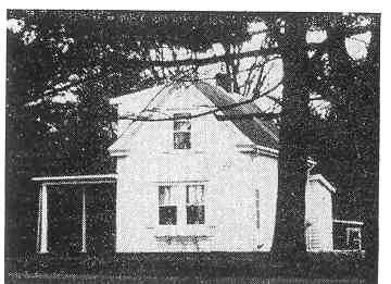
Some of the oldest houses in South Stoughton were built along Sumner Street, which once was a part of Pearl Street according to a former town engineer, At 434 Sumner Street is a much renovated house originally built by Samuel Monk in 1815. The Capen file lists it as built by Samuel Monk between 1815 and 1817, but the News-Sentinel list mentions only 1815. On the 1831 map, S. Monk is given as the owner. Little else is known about the builder except that he was a member of the Monk family.
An interesting example of the force of "tradition" is the attractive foursquare house at 480 Sumner Street, It has been called the oldest house standing in Stoughton, a tradition passed on by word of mouth but hot substantiated by documents. The Committee acknowledges it as one of the five oldest dwellings it discovered, accepting the date 1744 when Thomas Glover built it. It is also called the Elijah Glover house, but records indicate that Thomas was its original owner. On the Town list of houses built along Sumner Street, it is so listed: Thomas Glover, 1744; Elijah Glover, 1831 and 1854. On the map of 1749, Thomas Glover is the owner; the date given is 1749, a date repeated on the 1929 inventory, and in the Album at the Historical Society. The Wm. Capen collection and some old pictures in it gives the date as 1744; another old picture dates it "about 1750." Frank Reynolds agreed with 1744, as did the News-Sentinel file on Ancient Houses. Since the old Town street lists bear a measure of authenticity, the date 1744 was agreed upon. The Glover farm was said to be a very large tract of land, and valuable enough to be traded for military service.
One of the largest land owners in this area was Samuel Shepard, who built the house at 541 Sumner Street in 1768. It appears on the Town list of houses on Sumner Street as standing in 1775, built in 1768 by Samuel Shepard; the 1794 map shows him still as the owner; the 1831 and 1854 maps give Peter, then G. S. Stetson as owners (the second story was added in 1854); in 1876, it was still in the Stetson family. The 1929 inventory and the Historical Society Album both claim the house as standing in 1768, owned by Sam. Shepard; the Album also notes he was married in 1761. The Capen collection suggests the house may have been built just behind Ash Street near the old Bridgewater Road which was discontinued in 1771 when Park Street was altered, but this may refer to one of the other Shepard houses in the area (see Packard).
The Shepards were evidently an old family in Stoughton even before the 1760's. Huntoon lists a John Shepard as living in Stoughton before it was incorporated as a town; when it was set aside in 1726, he was honored with many positions in the community, including Representative to the General Court in 1753. Samuel Shepard was also a public servant; in 1778, he was one of a committee in Stoughton to approve or disapprove the draft of the new Massachusetts Constitution.
His daughter, Hannah, and son, Lemuel, both lived in south Stoughton; present Cedar Street was the "old road" from Shepard's to his son, Lemuel's, home which stood about where 115 Cedar is now located. He donated the land for Ash Street for a "new road" to Park Street so the Shepard, Sumner, and Packard children could get to the school on Park Street more safely, according to one local historian.
There is some confusion about the origin of the house at 204 Cedar Street (renumbered from 104 in recent years), but it is definitely the William Packard house, generally acknowledged as built in 1768. The Town list and News-Sentinel inventory both say it was one of three houses built by the Bartlet's near the Bridgewater (Brockton) line around Park Street; both Benjamin and Edward Bartlett are mentioned, but who owned which house has not been identified. One of the three houses, however, was known to have been moved to 104 (204) Cedar Street. The 1794 map shows Edw. Bartlett with a house in this location between Park and Sumner Streets, the 1831 map gives Wm. Packard near Sumner Street. The 1931 list gives the date of the Wm Packard house as 1768. Other names have been associated with it, like Stuart Esty and Ralph Shepard, but the date is generally fixed as 1768.
Local history says this house was given to Hannah Shepard in her father Samuel's Will; Hannah was the wife of William Packard. Since the present owner also says the house was moved from Camden Street near the Brockton line leaving a still visibly cellar hole, this seems to corroborate the Capen file that Samuel Shepard moved a house from near the old Bridgewater Road to the Sumner Street area; it is possible he left it at 104 Cedar Street, not 541 Sumner Street. The first floor of the house is probably original; it has a peculiarly vaulted kitchen ceiling. The present sitting room is believed to have been used as a boot shop, as was the custom in many of the old houses in this area.
William Monk House. Torn down in the 1990's. Possibly not the original 18th century home, which may have burned. This site now is a new road off Park St.
Returning to the Square by way of Park Street there are three early dwellings of note. At 709 Park Street is a small home set back from the street which was built by William Monk in 1765; the house is said to have been cut in half at one time, and the front part now standing is very old. The Historical Society Album gives the building date as 1763-5; William Monk was shown on the 1775 map as the owner. Both the Capen File and News-Sentinel article use these dates and original owner. The 1794 map shows it as Wm. Monk's house; the 1831 map lists Lemuel Monk; the 1854 map, Eliphelit Monk; these dates and names are recorded on the Town List for Park Street as well. The Album also notes that Wm. Monk built this house on land given to him by Thomas Giover in 1763 for substituting for him in military service in the war of 1756-63, a common practice in Colonial days.
On the other side of the street, closer to the Square, are the two Swan houses. At 550 Park Street is the house built by James Draper Swan in 1795; this may have been built on the site of an earlier Swan house. The present house, greatly added on to in later years, first appears on the map of 1831 as built in 1795 by James Draper Swan, The Capen file verifies the date and original owner.
One of the five oldest houses in Stoughton is the charming Cape built at 540 Park Street by Major Robert Swan in 1746. The map of 1749 shows a Robert Swan house; the Historical Society Album lists it as built in 1746-9, and that Maj. Robert Swan owned it in 1775. The 1794 map shows Maj. Swan here; by 1831, the owner was listed as J. Swan. The present owner said the house was definitely Maj. Swan's during the Revolutionary War. Even though both the Capen File and News-Sentinel list date it at 1749, the Committee accepted the date of 1746 as the earliest known, since the map of 1749 tends to date homes as standing in 1749.
Major Robert Swan was a prominent Stoughton citizen during the important Revolutionary era. He was noted by Huntoon as one of three Stoughton military men who drilled the local Minute Men. He was also one of four men who were commissioned to work out the division of Stoughton and Canton in 1782. He must also have supported the Singing School established at Robert Capen's Tavern by the famous singer and composer, William Billings. His daughter, Lucy Swan, was one of Billings' pupils (Huntoon remarks "she sang treble"); in July, 1774, Billings and Lucy were married and left for Boston.
Leach Street, a short street off Park Street, is not on the early maps, but one of the old houses now situated on it has an interesting background. At 27 Leach Street there is a residence which was originally the West Stoughton School house built on Central Street in 1818. The Tax list shows that a school was built in 1818 near Belcher Corner; the 1831 map shows the old school house on Centra! Street. Some time before 1848 this school was moved; about 1848, it was decided a new school was needed in this section, and so one was built near the Southworth houses. On the 1854 map, the old 1818 school is no longer shown, but the newer one named the Adams School is shown. Within present memory, the Adams School was razed, but the old West Stoughton school is still lived in on Leach Street.
The Capen collection notes the 1818 school house at 27 Leach Street in its list of "Old Homes." The News-Sentinel adds that the 1818 West Stoughton School house, built in 1818 on Central Street, has been moved twice, A previous owner said the first move was to Chestnut and Seaver Streets; the present owner believes the house was moved to its present site about 1906. This house has been documented by its owners in Dedham.
James Hill House - demolished in the 1990's for a parking lot for the Randolph Savings Bank
The main street leading from the Square to North Stoughton is Pleasant Street. Two houses near the Square belong to the new industrial era which came in during the early 1800's. The James Hill house, built at 25 Pleasant Street about 1821 demonstrates a new elegance suited to the prosperous merchants. The News-Sentinel says James Hill built the house in 1821 (it was misnumbered 52 in the list); the Capen collection gives the date as 1821-9. There is still some question on the date, since "the 1831 map does not show the house, and the 1854 map notes Hill and Drake in this location. But the Committee accepted the Capen file as its authority in dating it.
The firm of Hill and Drake were shoe manufacturers; they conducted an extensive business in the South before the Civil War and both .built homes suitable for entertaining their southern customers. In 1854 and later, Henry Fitzpatrick, also a shoe manufacturer (and one of the original Public Library Trustees) owned the house at 25 Pleasant Street. Some local people still know it as the Fitzpatrick house,
James Hill's partner, Capt. Henry Drake, built a similar house at 69 Pleasant Street about the same time, 1821. This house was later owned by the Monk family, prominent in Stoughton affairs, who knew its background. The house has beautiful handmade woodwork and marble fireplace mantles. In the early 1900's, the Hill, Drake, and Atherton (old Chicataubut Club) homes were the finest in town, according to a descendant of the Monk family.
A little farther up Pleasant Street stand three much older small houses. At one time or another all three appear to have belonged to Christopher Wadsworth, who owned a great deal of property in Stoughton. In researching old deeds, his name was often listed as an owner, even if for a short time, during the Revolution; it was almost as if he bought up farms at every opportunity. In 1760, the News-Sentinel had him owning a farm on School Street which has only recently been torn down for a housing development; in 1775, he owned the three houses on Pleasant Street. Huntoon relates that in 1776 Chris Wadsworth was part of a Committee to consider a resolve from the General Court to form a new Massachusetts Constitution; in 1780. he was noted in a Capen file of families as being a Representative
The house at 137 Pleasant Street is given in the Historical Society Album as built in 1775, with Christopher Wadsworth as the owner; the Capen collection agrees with this On the map of 1794, Silas Kenny is shown as the owner; the Album also states Silas Kenny lived there in 1794. The present owners are involved in searching the deed for further information
Next door to this is an aid saltbox house, at 145 Pleasant Street, which is rather unique. The Album states this house was once the barn for the Wadsworth house at 137 Pleasant Street. It was moved slightly and altered to make a "tenement " Since it does not appear on the map of 1794 or 1831 as a house, the barn was probably converted some time after these dates. However, it is accepted as belonging to Christopher Wadsworth in 1775.
Across the street at 756 Pleasant Street stands the third Wadsworth house. The Album states this was standing in 1768, and that in 1775 Christopher Wadsworth was the owner. The-1929 inventory agrees that Wadsworth owned it in 1775. The Capen file lists the house as built in 1768 by Chris, Wadsworth, but the News-Sentinel give; John Osgood, Jr. as the owner in 1768. The 1794 map shows a house here owned by Hayden as does the 1831 map It would appear to be another piece of property bought and sold by Wadsworth. The Committee chose John Osgood, Jr. as its original owner.
Back to the Table of Contents To the next section...
Back to the main page of www.StoughtonHistory.com