CHAPTER I
BRIEF BACKGROUND OF HISTORICAL STOUGHTON
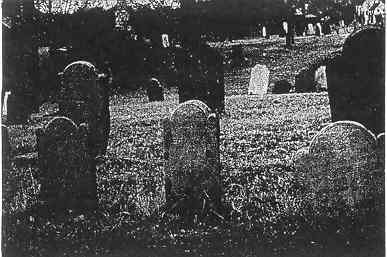
Pearl Street Cemetery
In 1967, Bertha Reynolds supervised the listing of certain historic areas and buildings for submission to the Massachusetts Historical Commission. She prepared an introduction to the Inventory of the "Historic Sites and Survey" which is briefly quoted here as background for our updated work.
In the Massachusetts Bay Colony, the area of Stoughton belonged to the South Precinct of Dorchester which extended from the Blue Hill range southward into the wilderness, and included a reservation for the Ponkapoag Indians. Stoughton was bordered on the west by an Indian trail which followed high land between swamps, being the only easy land route from Massachusetts Bay to Narragansett Bay. It is the historic Bay Road, and the first settlers took up land near it, on what is now West Street. Other settlements formed and, with the building of roads, came to cluster around road intersections. The town lies between the [roughly parallel) Bay Road, the Washington Street highway, and the Boston - Taunton Turnpike.
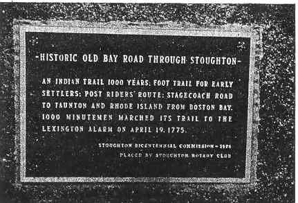
Original Bay Road Plaque from 1976
HISTORIC OLD BAY ROAD THROUGH STOUGHTON
An Indian Trail 1000 Years, Foot Trail for Early
Settlers : Post Riders Route :Stagecoach Road
to Taunton and Rhode Island from Boston Bay.
1000 Minutemen marched its trail to the
Lexington Alarm on April 19, 1775.
Stoughton Bicentennial Commission - 1976
Placed by Stoughton Rotary Club
Industries began around water power (Factory Village at West Stoughton), but introduction of steam soon scattered them through the town, often on the grounds of the homes of the owners. Boot and shoe manufacturing predominated at first, but Stoughton has been noted for the variety of its products: granite from its quarry, textiles (wool and cotton), rubber fabrics, sportswear, the invention of packaged popcorn, shoe lasts, shoe dressing, metal products and finally electronics,
As to homes for its people, Stoughton consisted, up to about the turn of the century, of villages of single homes separated by woods and farms. North Stoughton had a church and store, South Stoughton a railroad station, West Stoughton several factories. Each had a District School. The Center had stores which sent out trading wagons to the outlying districts. Gathered there were the churches, and, from about 1870, a high school and public library. From old maps which give the names of home owners in farming areas, we can trace some old houses, but many have been destroyed by fire or otherwise, and the survivors are altered for modern use.
Miss Reynolds divided the areas of study into (1) the Square and environs, (2) West of the Square, the railroad area, (3) the Dry Pond area, West Street and Bay Road, and (4) the intersection of Turnpike and Central Street.
The authentic history of Stoughton was written by Daniel Thomas Vose Huntoon in his History of Canton, which is the basis of most information about early days of Stoughton, Canton was separated from Stoughton in 1797; prior to that date, the area was all known as Stoughton.
The Ponkapoag Indians previously mentioned belonged to the second "Praying Town" established by John Eliot, signifying they were Christian Indians. As early as 1636, it was recorded that Chief Kitchamakin sold all his Sand (from Blue Hills Reservation through to Braintree as far as Easton) to one Richard Collicut of Dorchester, for 28 fathoms of wampum, reserving 40 acres of his choice for himself and his men. This deed was witnessed by Humphrey Atherton and John [Wiswall], The Ahauton family, first mentioned in 1667, figured in the area history right through to the 1800's. The older Ahauton was an educated Indian; his son William was a teacher, a councilor of the sachem, and signed several treaties before 1675. In 1690, he visited Major General Stoughton to assure the safety of friendly Indians. Another familiar Indian name is Charles Chicataubut, who petitioned William Stoughton and Joseph Dudley to be his guardians in 1781. But by 1726, the Ponkapoag Indians were reduced to but a few families; their remains lie in the Indian cemetery off Indian Lane. !n 1854, the Honorable Charles H, French built a stone house on what was supposed to be the site of William Ahauton's wigwam near Squaw Rock. It was not until 1861 that guardians were abolished and the Indians in Massachusetts were given citizenship.
There were several blacks living in Stoughton in colonial days. Isaac Williams was the first "colored man" listed in Canton (Stoughton) in 1719. He was a slave of Dr. Williams, subsequently married to Elizabeth Wills, a "pure Ponkapoag," and accepted into the tribe. Isaac bought land on which he built a house in 1803; the cellar-hole was still visible on York Pond Road in 1888. Amasa Williams, his son, died in 1827. In 1734, there were three slaves owned in Stoughton, belonging to Isaac Royall, Captain John Shepard, and Ebenezer Maudsley (Mosley). By 1741, eleven slaves were recorded, belonging to Ralph Pope, Nathaniel Maudsley (Mosley), and Deacon Joseph Tucker.
On December 22, 1726, the South Precinct became Stoughton, named for Lieutenant Governor William Stoughton. William was born in 1631 in Dorchester, the son of Colonel Israel Stoughton, who owned much land in Dorchester. William rose to become Lieutenant Governor in 1692; he was also Chief Justice of the Salem Witchcraft Trials. An early map of Canton (Stoughton) shows a large fam belonging to Colonel Stoughton.
A Committee chosen to select the second minister in the Parish (the first was the Reverend Joseph Morse) consisted of Isaac Stearns and John Wentworth, The Reverend Samuel Dunbar, who was to serve Stoughton for many years, accepted the call on September 23,1727. Huntoon says that "Deacon Stearns was an old one-eyed hypocrite and a lying old sinner"! His was the first house built in present Stoughton in 1716, "on the west side of the crossroad from French and Ward's toward Dry Pond (West Street)."
The Dunbar family was prominent in Stoughton's history, from the fiery sermons preached by Samuel, to the civic activities of his son, Elijah, it was Samuel Dunbar who fired the meeting at Doty's Tavern, inspiring them to meet again to draw up the Suffolk Resolves. Elijah became active in the political and social gatherings in Stoughton, He dearly loved a "sing," joining the groups who gathered at various private homes and taverns for the pleasure of singing together; it was he who started the first musical society.
Huntoon records that a singing meeting in Stoughton was mentioned in 1762; that there was evidence of an organization in working order to practice vocal music in 1764. The famous singing school of William Billings met in 1774 in Robert Capen's Tavern; the list of its scholars includes at least 26 women, one of whom was Lucy Swan, whom Billings married in 1774. In 1786, the Old Stoughton Musical Society was organized, with the Honorable Elijah Dunbar as President; he served this post for 22 years. Elijah was reputed to own one of the finest collections of books on music in the country.
It was reported that from 1700, inhabitants of the "new Grant" increased in numbers and material prosperity. The ratable polls in 1727 were 180; there were 121 houses, 763 cattle and horses, 6 or 7 sawmills, 2 grist mills, and 4 iron works. From 1727 for nearly 100 years, residents of Sharon, Stoughton, and Canton fought the mill owners to keep the Neponset River open for fish. The land between present Stoughton and Canton was still called Mount Hunger Fields. By 1769 the population of Stoughton was about 2100. "The inhabitants were primitive in manners; their wants were few; most were not educated except by experience; they looked to a few men for advice, who were acknowledged leaders." In 1785, it was voted that the Town Clerk should record all births and deaths; there were 155 voters listed in (now) Stoughton, ^ko in (now) Canton; 1125 acres of unimproved land were recorded in present Stoughton, 622 acres in present Canton.
In 1783, Elijah Dunbar and Jedediah Southworth walked to Boston to the General Court to see about having the Parish of Canton set off from Stoughton, By 17%, the Parish had decided on the name of Canton; the 2nd Precinct, "the comparatively newly settled neighborhood," was given the old name of Stoughton. In 1797, Canton was formally made a separate town.
From this very brief background, it can readily be seen how the history of a small town is reflected in the lives of the men who "were acknowledged leaders," and in the homes they built for their families. The Southworths, Capens, Athertons, Cranes, and Talbots figured prominently in the first 100 years of Stoughton; the family names are still known in the community.
Back to the Table of Contents To the next section...
Back to the main page of www.StoughtonHistory.com