Stoughton in 1890
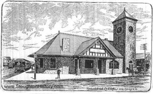
Stougton Railroad Depot built in 1888 on Wyman Street.
also including Sharon, Canton and Avon.
STOUGHTON
lies in the southwesterly part of
Canton
bounds the town on the north,
The
value of the products of the 78 farms, reported in the census for 1885, was
$82,866. There are 12 boot and shoe factories, employing nearly 900 persons, and
making goods to the amount of $ 884,516; and a woolen mill and dyehouse,
employing nearly 200 persons. Other manufactures were leather, knit hose, rubber
goods, shoe lasts, machinery, artisans’ tools, paper boxes, carriages,
clothing and dress trimmings, soap, and food preparations. Steam is the chief
power used. The value of the textiles made wag $419,000; and of all
manufactures, $1,469,185. There is here a co-operative bank, aiding the people
in establishing homes. The population was 5,173; of whom 1,376 were legal
voters. The valuation in 1888 was $2,031,731, with a tax‑rate of $15.50 on
$1,000. There were 908 taxed dwelling-houses. The school system is graded,
consisting of primary, grammar and high; occupying 11 buildings, valued at some
$50,000. There is also a private school – “St. Mary’s.” There is a
commodious town-hall, erected in 1881 at a cost of $45,000. The public library
contains nearly 5,000 volumes. The local newspapers are the “Record,”
“Sentinel,” “ Journal” and “Citizen,” - all weeklies. The churches
are one each of the Congregationalists and Universalists, and two each of the
Methodists and Roman Catholics.
The
Indian name of
“This is a small town, and hath not above 12 families in it, and so about sixty souls. This is the second praying town. The Indians which settled here removed from Neponset Mill. The quantity of land belonging to this village about 6,000 acres; and some of it is fertile, but not generally as good as in other towns."
This
town, was detached from
CANTON
is an active manufacturing and farming town, lying a little east of the centre
of
On
the northeast side “lie the towns of - Milton and Randolph, on the south and
southwest are
The
scenery of this town is varied and picturesque. There are elevations at the
south and centre; and on the northeastern border is Blue Hill, which rises to a
height of 635 feet, commanding a magnificent view of
The
manufactories in this town consist of a branch shop of the Ames shovel
factories, an iron foundry, copper works, one factory for making shoe-tools, two
for cotton spinning rings, one for stove polish (Rising Sun), one making paper
boxes, one for cotton one for twine, one for fish-lines, one for oil-cloth, six
for fancy woolens, and one for silk goods. The last employs about 400 persons;
the copper works and the iron works each about 300. The value of the textiles
made in 1885 was $1,338,640; and the aggregate value of the manufactures was
$2,703,327. 'The Neponset National Bank has a. capital of $250,000. The Canton
Institution for Savings, at the close of last year, held deposits to the amount
of $553,682. The valuation of the town in 1888 was $3,540,727, and the tax-rate
$14 on $1,000. The population in 1885 was 4,380; of whom 980 were voters.
The
Baptist society was organized in 1814, the Congregationalist in 1828. Other
churches are the Unitarian, the Universalist and the Roman Catholic.
This
town was detached from the northerly part of
Canton
added 350 men to the Union forces in the late war, which was 23 above its quota
Twenty-nine of these perished in the service. The climate of this town
is salubrious and agreeable, the Blue
Hills protecting a considerable territory from the northeast winds. The roads
are numerously bordered with elms of large size, and shaded in some parts by
original forest, making pleasant summer drives. Hon. F. M.
Ames and T. B. Aldrich have residences here, which they occupy in the
summer months. This town is also the home of Hon. Elijah Morse, well known to
the people of
Of
the eminent men of the past,
SHARON
occupies the highlands which form the water-shed of streams flowing in opposite
directions northeasterly towards
The
assessed area of the town is 13,764 acres. There are above 6,000 acres of
forest, including white and pitch pine, oak, elm, chestnut and maple. The flora
generally is rich and various. There is found here a wood violet that is very
large and fragrant. The chief rock is sienite, and there is much iron‑ore
at one or more places. The whole
extent of the town is elevated from 300 to 530 feet above sea‑level. The
highest point of land is Moose Hill, in the western section, which commands one
of the finest prospects in the county.
Near it on south and east rise three bold eminences, - Bluff, Hobb's, and Bald
hills. In the southeast section is Rattlesnake Hill, and in the southwest are
Bearfoot and Cow hills, between which run a lively streamlet and numerous
railroad trains. Besides several millponds there are two natural lakes,
Wolomolpoag (Indian meaning “sweet water”) among the hills near the centre,
and Massapoag (“large water”) beyond the hills a mile southward. The first
has an area of 16 acres ; the last of 435. Around it are summer residences and
three or more hotels. Puffer's Brook and the outlets of these ponds are feeders
of the
The
soil is loamy and fertile. Large quantities of timber, firewood, charcoal and
bark are sent to market. Many acres are devoted to cranberries and strawberries,
and apple and other fruit trees are numerous. Large market-gardens and poultry
farms are found here. The aggregate value of the product of the 73 farms in the
town in 1885 was reported in the State census as $70,006. A duck, a cutlery and
a trowel factory employ about 75 persons. Other manufactures are carriages,
boots and shoes, lumber, boxes, leather, polishes and wrought stone. The value
of the goods made was $128,208. The population was 1,328, including 338 legal
voters. The valuation in 1888 was $ 1,107,677, with a tax-rate of $10 on $1,000.
There were 335 taxed dwelling-houses. There is a very good town-hall, a public
library of about 3,000 volumes, and graded schools, including a high school.
These are supported partly by an invested fund. The five school-houses are
valued at about $9,000. The three churches are Congregationalist, Baptist and
Unitarian. Two weekly papers are issued here, called the “Advocate” and the
“Ozone.”
The
original name of this township was Massapoag, but it. was later known as
Stoughtonham. On
The
town is remarkable for the charm of its scenery, the excellence of its
atmosphere and the longevity of its inhabitants.
AVON
is a young, enterprising town in the southeastern part of Norfolk County,
17 miles south of Boston on the Old Colony Railroad, Fall River Branch, which
forms a part of the line of the town on the northwest side, The main line to
Cape Cod crosses the southeast corner of the town, where there is also a
station. Stoughton forms the west and northwest boundaries Holbrook the
northeast and east, and Brockton the south.
The
assessed area is 2,428 acres, about one fourth being wood land, chiefly maple,
with some pine. The highways are excellent, and throughout the town axe much
ornamented by elms and other trees, many of large size. The surface is
pleasantly diversified by hill and valley, and drained by affluents of Taunton
River. Mine Hill, about 250 feet high, on the boundary line between Avon and
Stoughton, marks the water-shed between Boston and the South shore. The rock is
sienite, in which beds of iron ore occur. The soil is a black loam, rocky and
hard to work.
The
population is about 1,500, with some 300 dwellings. Farming is carried on to the
usual extent and profit, but the chief business is manufactures, ‑ mostly
boots and shoes. There are two large factories and a small one of this kind.
Avon’s proportion of the aggregate value of manufactured goods in Stoughton
(of which at the last census it formed a part) is about $ 375 ,000. - estimated
on the basis of assessed persons and valuation on May 1, 1888. The number of
assessed persons was 404, while the valuation was $527,375.
Of the village of Avon (then East Stoughton), a writer in the “Boston Traveller” said several years ago:
“This brisk and wide-awake village is making boots for the million; and, by the good old honest way of hard work and fair dealing, is accumulating
greenbacks, and keeping pace with the general run of things in this Commonwealth. The people are too busy to trouble each other, and too well oftefto move away; and so a peaceful, industrious, contented, and increasing population crowds the place. Wages are good; living is low; and those willing to labor - and there are but few who are not - find enough to do, and come to plenty. This the snug and tasteful cottages, the pleasant gardens, the well-dressed and fine-looking children, amply manifest
“What
a change has well-directed industry effected in this village in the last three
decades of years! Thirty summers ago, a dull, drinking, droning 'corner,' a few
old houses, and a country store retailing, on long credits, codfish, mackerel,
molasses and New England rum; now a thriving town, with busy manufactories,
noble private dwellings, churches, school-houses, handsome
Streets adorned with shade-trees, and the elements of' ‘health, peace,
and competence’ (which Pope puts down as the grand trio of the graces which
make up the happy life) distinctly visible on every hand. Every breeze that
sweeps along brings ‘health;’ no meddlesome and story-telling neighbors mar
the ‘peace;’ and as to ‘competence,’ one has but to stay, and stick
closely to the last, and he is sure of it.” The region is undoubtedly
salubrious; and the census of 1885 shows that there were then 56 residents, of
the two towns who were over 80 years of age.
The
Indian name of
Stoughton
was formerly a part of
SOURCE: George J. Varney and Rev. Elias Nason, M.A., A gazetteer of the State of Massachusetts with numerous illustrations. (Boston, Mass., B.B. Russell. 1890), Stoughton, pgs. 620-622; Sharon, pgs. 588-589; Canton, pgs. 220-222; Avon, pgs. 128-129.
Back to Main Page at www.StoughtonHistory.com